The descriptions of the forest types have tables with the species found in addition to topographical maps with the collection locality numbers on them. Those collection locality numbers are listed below together with the location description and all the collections made at each location with the collection dates.
- A collection numbers that have no prefix exist as herbarium material. They should have the prefix "SMHI" added, e.g. 1001 - 1009 should be SMHI1001 - SMHI1009. For specimens with large, soft fruits or fleshy flowers there might be material in a spirit collection. The collection number attached to the spirit material is the same as the herbarium material
- The numbers with the prefix "F" are ferns.
- Those with the prefix "MK" were collected as living material. The living material was always split into two sets with one set being dispatched to the Royal Botanic Gardens Kew and the Hortus botanicus in Leiden. Little survived the transport to Kew, but the material arrived well in Leiden and some is still growing there today. In some cases material in spirit exists for the MK collections.
- All wood samples were initially catalogued into the Rikshebarium collection.
The herbarium material was distributed to these seven institutes (the Riksherbarium holds additional duplicate material):
- Arnold Arboretum (A)
- Bogor Herbarium (B)
- Forest Research Centre at Sandakan (San)
- Forest Research Institute at Kepong (Kep)
- Philippine National Herbarium (PNH)
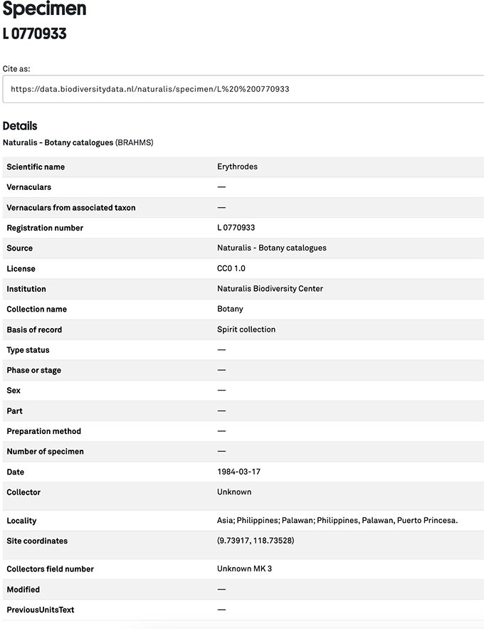
- Rijksherbarium (L)
- Royal Botanic Gardens at Kew (K)
Searching for material of all types and viewing herbarium material is simple where the collections have been digitised. The Rijksherbarium is now the Naturalis Biodiversity Center and all collections can be easily searched for using the advanced search at https://bioportal.naturalis.nl/en. Records look like this:
The Kew collections can be searched using the advanced search at https://data.kew.org/records/#tab_advanceSearch A typical search result looks like this:
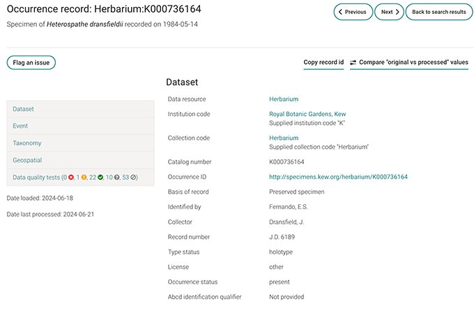
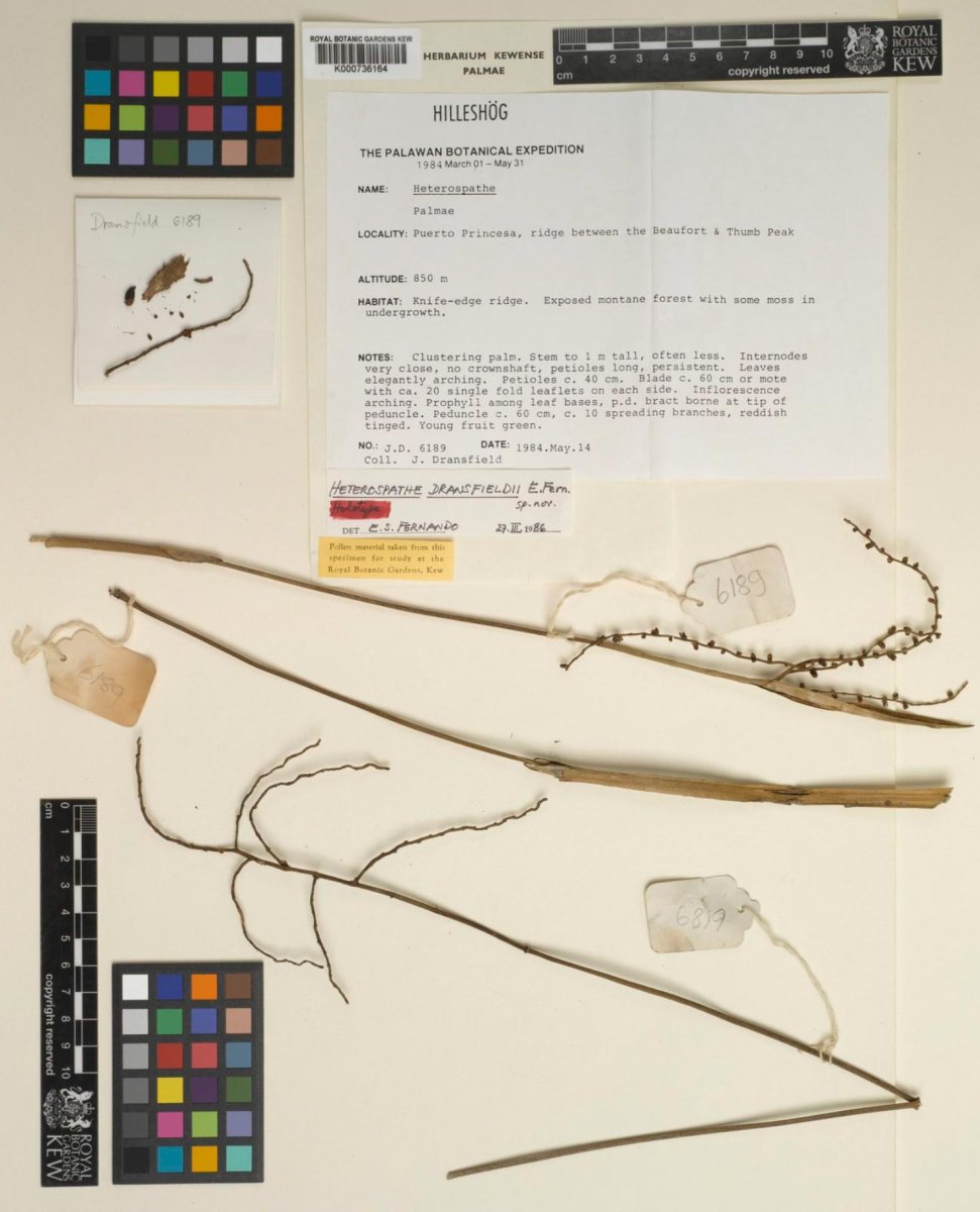
The associated image is:
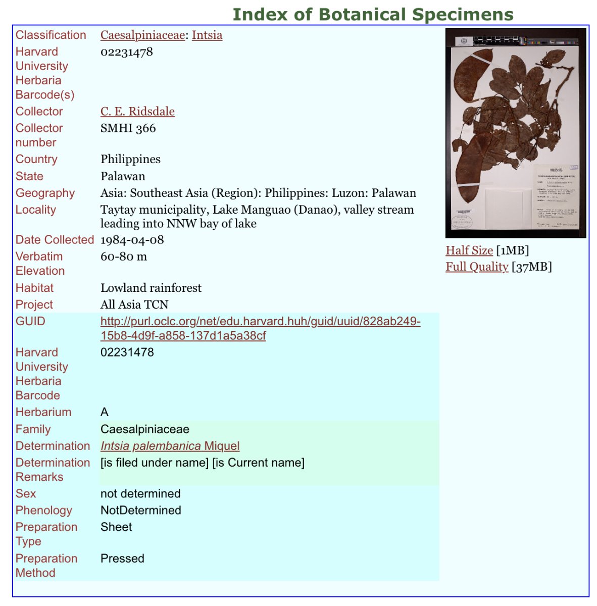
The Arnold Arboretum has a similar digital search system
The specimen record for Instia palambanica looks like this:
A herbarium or spirit collection can be tied back to the collection locality and date as a check through the listing below:
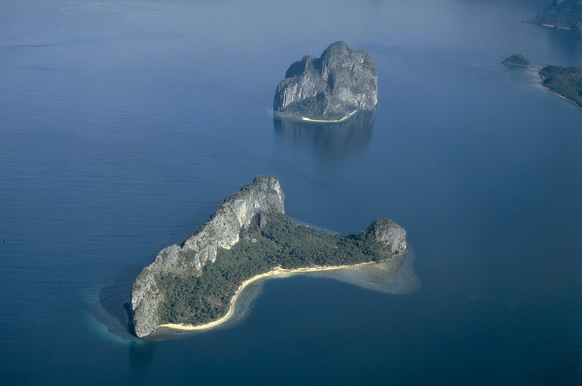
1. Puerto Princesa municipality, Irawan River valley head on the lower slopes of Mt. Beaufort; closed broadleaf rainforest on medium slopes; alt. 150 - 170 m.
- 1984.March.10: 1, 501, 1001 - 1009, MK1 - MK2
- 1984,March.11: 2 - 16, 1016 - 1018
- 1984.March.12: 17 - 34, 1019 - 1023.
- 1984.March.14: 1024 ~ 1027
- 1984.March.15: 1028 - 1037
- 1984.Mareh.16: 541 - 542
- 1984.March.17: MK4
- 1984.March.19: 145, 152 - 153, 155 - 156
- 1984.March.20: 158 - 159, 161 - 162
- 1984.March.21: 617 - 622, F2, MK22, MK26 - 28, MK31 - 56, MK58 - 67, MK73 - 75, MK78
- 1984.March.22: 185
- 1984.March.24: MK84 - 86
- 1984.March.29: 698
- 1984,.March.30: 289 - 300.
- 1984.April.14: 1685 - 1694
- 1984.May.15: 6191
- 1984.May.29: 1854 ~ 1880, 2165 ~ 2177
2. Puerto: Princesa municipality, Mt. Beaufort, NNW spur, east side; closed broadleaf rainforest with Agathis; alt. 550m.
- 1984.March.12: 502 - 527
- 1984.March.13: 35 - 40, 1010 - 1015
- 1984.March.14: 528 - 540, MK7 - 10
- 1984.March.20: 592, MK20 - 21, MK23 - 24, MK29 - 30, MK76 - 77
- 1984.March.22: 184
3. Puerto Princesa municipality, Irawan R. valley head, riverine forest; alt. 150 m.
- 1984.March.14: 41 - 62
- 1984.March.15: 63 - 91, 120A - 127
- 1984.March.21: 181 - 183
- 1984.March.30: 285 - 287
4. Puerto Princesa municipality, Irawan R. valley head, north side; closed broadleaf rainforest on a rocky slope; alt. c. 170 m.
- 1984.March.17: 113 - 120
- 1984.March.18: 128 - 144
- 1984.March.19: 146 - 151, 154
- 1984.March.20: 160, 163 - 168
- 1984,March.21: 169 - 180
- 1984.March.30: 288
5. Puerto Princesa municipality, Irawan R. valley, east side; semi-deciduous forest; alt. c. 120 m.
- 1984.March.22: 186 - 197
- 1984.March.24: 198 - 208
6. Puerto Princesa municipality, Irawan R. Valley, Mt. Beaufort, west spur, north side, east end; montane rainforest by chromite mine; alt. 615 m.
- 1984.March.28: 231 - 235
- 1984.March.29: 239
7. Puerto Princesa municipality, Mt. Beaufort, NNW spur, east side; closed broadleaf rainforest; alt. 230 - 380 m.
- 1984.March.17: 543 - 566, MK3, MK5
- 1984.March.18: MK6, MK11
- 1984.March.20: 593 - 616, Fl, MK19, MK23, MK5
- 1984.March.21: F3 - 5
8. Puerto Princesa municipality, Mt. Beaufort, North spur, west side, old track; closed broadleaf rainforest on steep slopes; alt. 350 - 400 m.
- 1984.March.19: 567 - 587, MK25
- 1984.April.14: 1681 - 1684
9. Puerto Princesa municipality, Mt. Beaufort, main track from Irawan River to ENE spur; closed broadleaf rainforest; alt. 420 m.
- 1984.March.19: 588 - 591, MK17 - 18
10. Puerto Princesa municipality, Mt. Beaufort, NNW spur, west side; montane rainforest on steep slope; alt. 630 - 650 m.
- 1984.March.22: 623 - 654, MK68 - 72, MK79 - 83
- 1984.March.26: , 690 - 692, MK87 - 92
- 1984.May.29: 1869 - 1880
11. Puerto Princesa municipality; Irawan River valley head, NNW side; alt. 180 - 200 m.
- 1984.March.19: MK12 - 16
- 1984.March.28: 655 — 658
12. Puerto Princesa municipality, Mt. Beaufort, W spur, ridge with peak spot height of 862 m; upper montane rainforest; alt. 750 = 862 m.
- 1984.March.28: 209 - 230, 659 - 668, MK94 - 114, MK118 - 119, MK122 - 129, MK131 - 133, MK135 - 136
- 1984.March.29: 236 - 284
- 1984.April.14: 1675 - 1680
- 1984.May.14: 6189, 6190
13. Puerto Princesa municipality, un-named peak with spot height of 930 m to WNW of the NNW spur of Mt. Beaufort; upper montane rainforest; alt. 850 - 930 m.
- 1984.March.29: 669 - 689, 693 - 697, MK93, MK115 - 117, MK1i20 - 121, MK130, MK134
14. Taytay municipality, Lake Manguao (Danao), bay in NW corner; lowland rainforest; alt. 50 m.
- 1984.April.04: 301 - 310, 699 - 707
- 1984.April.06: 327 - 328, 341 - 350
15. Taytay municipality, Lake Manguao (Danao), spur in NW corner of the lake; alt. 50 - 90 m.
- 1984.April.06: 329 - 340
16. Taytay municipality, Lake Manguao (Danao), valley stream leading into NNW bay of lake; lowland rainforest; ait. 60 - 80 m.
- 1984.April.05: 311 326, 708 - 738, MK137 - 138
- 1984.April.06: 739 — 756
- 1984.April.07: 351 - 362, 757 - 771, 776, MK139 - 142
- 1984.April.08: 363 - 374
- 1984.April.09: 377 - 390
17. Taytay municipality, Lake Manguao (Danao), near resthouse in NW corner of lake; lowland rainforest; alt. 50 - 60 m.
- 1984.April.08: 375 - 376, 772 - 775, 777 - 782
- 1984.April.12: 421 - 426, 814
- 1984.April.26: 1550 - 1551, MK179, MK182
18: Taytay municipality, Lake Manguao (Danao), SE.corner, track going south for c. 3 km; closed broadleaf rainforest; alt. 50 m.
- 1984.April.10: 391 - 395, 783 ~ 795, MK143 - 147
19. Taytay municipality, mid-point between Calauag and Salider Point, near the 32 m spot height; open broadleaf rainforest.
- 1984.April.11: 396 = 406, 411 - 420, 796 - 812, MK148
20. Taytay municipality, Calauag; alt. 10m; regrowth.
- 1984.April 11: 406 - 410
21. Taytay municipality, 25 - 30 km north of Taytay on the track to Liminangcong; alt. 50 m.
- 1984.April.12: 815 - 816
22. Langen (Malapakan) Island, west central karst outcrop with the spot-height of 322 m.
- 1984.April.14: 427 - 436, 817 - 832, MK 149 - 154
23. Langen (Malapakan) Island, Malapakan Cove, cove edges and a forest to 20 m; closed broadleaf rainforest.
- 1984.April.14: 833 - 834
- 1984.April.15: 437. - 445, 836 - 847, MK155 - 161
- 1984.April.16: 44@ ~ 464, 871, MK162 - 168
- 1984.April.17: 465 ~ 468
24. Langen (Malapakan) Island, south side of valley north of Malapakan Cove; open broadleaf rainforest; alt. 10 - 120 m.
- 1984.April.16: 848 - 870
25. Langen (Malapakan) Island, ridge and its north side between Malapakan Cove and Bocal Bay; open broadleaf rainforest; alt. 150 - 120 m.
- 1984.April.17: 469 - 473, 872 - 879
26. Pagdanan Range, Ibangley Brookside Hill; closed broadleaf rainforest; alt. 40 m.
- 1984.April.21: 474 - 500, 880 - 912, F6, MK169 - 176
- 1984.April.22: 913 938, 1501 - 1510, MK177
- 1984.April.23: 956 - 965, 1526 - 1533
- 1984.April.24: 966 - 980
- 1984.April.26: F8 - F9, MK180
27. Pagdanan Range, 10 km east of San Vicente; closed broadleaf rainforest; alt. 170.
- 1984.April.23: 939 - 955, 1511 - 1525, F7, MK178
28. Taytay municipality, 15 km north of Embarcadero, area near Pancol; closed broadleaf forest; alt. c. 140 m.
- 1984.April.26: 981 - 990, 1534 - 1540, MK181
29. Taytay municipality, north of Embarcadero, area near Igang; Man-made savanna; alt. 30 m.
- 1984.April.26: 991 - 1000, 1540 - 1549
30. St. Pauls Bay, Mt. Bloomfield, lowlands to SSE; closed broadleaf rainforest; alt. c. 50 m.
- 1984.May.03: 1552 - 1562
- 1984.May.04: 1563 - 1567, 2000 - 2016, 6162 - 6165, MK232 - 233, MK207 - 208
31. St. Pauls Bay, Mt. Bioomfield, WNW to W face, chromite mine; very stunted open forest; alt. 150 - 200 m.
- 1984.May.04: 2017 - 2019, MK194
- 1984.May.05: 1571 - 1609, 6166 — 6168, MK206
- 1984.May.06: 1610 - 1627, 1673, 1674, MK212 - 213, MK234
32. St. Pauls Bay, 2 km north of Cabayugan, edge of National Park; closed broadleaf rainforest; alt. 50 m. 1984.May.04: 1038 - 1050, 2020, 6162 — 6164, MK183 - 193, MK226 - 227
33. St. Pauls Bay, Sabang beach; coastal forest; alt. 0 - 5 m.
- 1984.May.04: 1568 - 1570
- 1984.May.10: 1662 - 1669, 1671 - 1672
34. St. Pauls Bay, Cabayugan, major outcrop to the SE; open broadleaf rainforest; alt. (10) - 160 - 300 m.
- 1984.May.05: 2021 - 2033, 6169 - 6172, F10 - F16, MK195 - 205, MK 209 - 211
- 1984.May.06: 1051 - 1056, 1200 - 1219, 2036 - 2046, MK214 — 220, MK228 - 230, MK240
35. St. Pauls Bay, mining road from Cabayugan to Maratapi beach; regrowth; alt. 70 m.
- 1984.May.07: 1628 - 1640
36. St. Pauls Bay, Cabayugan, SSW of Lion's Cave; closed broadleaf rainforest; alt. 20 - 40 m
- 1984.May.07: 1641 - 1643, 2047 - 2062, 6173 - 6177
37. St. Pauls Bay, bay to east of Tuturinguen Point; closed broadleaf rainforest; sea level.
- 1984.May.08: 2063
- 1984.May.09: 1653 - 1661, 6178 - 6184, MK241
- 1984.May.10: MK221 - 225, MK235 - 239
38. St. Pauls Bay, Cabayugan Village, west side of road; regrowth; alt. c. 50 m.
- 1984.May.07: 1644 - 1653
- 1984.May.10: 1670, 2081 - 2082
39. Puerto Princesa municipality, c. 20 km north of city, vicinity of the Santa Cruz Resthouse; open broadleaf forest; alt. 40 m.
- 1984.May.10: 2064 - 2080, 2083
40. Puerto Princesa municipality, c. 36 km north of the city, vicinity of a Public Works Resthouse; open broadleaf forest; alt. 40 m.
- 1984.May.11: 1057 - 1068, 1220 - 1253, 6185 - 6168
41. Narra, Mt. Victoria, Trident Mining Co. area; closed broadleaf rainforest; alt. 490 - 590 m.
- 1984,May.17: 1254 - 1266, 1695 - 1716, 6192, 6193
- 1984.May.18: 1267, 1268, 1717 =~ 1742, 2084 - 2114, 6195 - 6197, F18, MK242 - 243
- 1984.May.19: 1270 - 1288, 1743 - 1758, 6198, 6199
- 1984.May.20: 1759 - 1781
- 1984.May.21: 1782 — 1806
42. Narra, Mt. Victoria, Trident Mining Co. area; regrowth on alluvial fan; alt. (10) -— 110m.
- 1984.May.18: 1269, 6194 - 6194
- 1984.May.19: 2115 - 2123, F17, MK244 - 245
- 1984.May.22: 1820 - 1846
- 1984.May.24: 1847 - 1853
43. Narra, Mt. Victoria, Trident Mining Co. area; montane rainforest; alt. 620 - 720 m.
- 1984.May. 20: 1289 - 1298, 2124 ~ 2154, 6200 - 6203, F19, MK246 - 251, MK287 - 289
44. Narra, Mt. Victoria, Trident Mining Co. area, valley leading SE of ridge at 480 m; closed broadleaf rainforest.
1984.May.21: 1782 — 1806 1984.May.22: MK278 - 284
45. Brookes Point municipality, Infanta Mining Co. area (c. 15 km north of Brookes Point); gallery forest; alt. 190m.
- 1984.May.21: 1299, 2155 - 2159, F20 - 22, MK252 - 277, MK285 - 286.
46. Brookes Point municipality, c. 50 km north, Pulot 'Tres'; closed broadleaf rainforest; alt. 190 m.
- 1984.May.22: 2159 = 2160, 6204 - 6207
47. Quezon, c. 15 km SW; alt. 190 m.
- 1984,May.24: 2160 - 2163, 6208 - 6209
48. Quezon, Tumarabong River; alt. 50 m.
- 1984.May.24: 2164